Ashland Forest Resiliency Project News (View All)
Section of Toothpick Trail Closed June 19 through June 23
Beginning on Monday, June 19 and extending through Friday, June 23; a section of Toothpick Trail will be closed from Tolman Creek Road to the border of the Rogue River-Siskiyou National Forest. Please see the map below for the location of the Toothpick Trail closure. Please use the Ashland Watershed Map to plan your route.
Due to hazardous tree removal and thinning for improved forest health, the Tolman Creek end of Toothpick Trail (which is on private property) will be closed for your safety.
Closure area map:
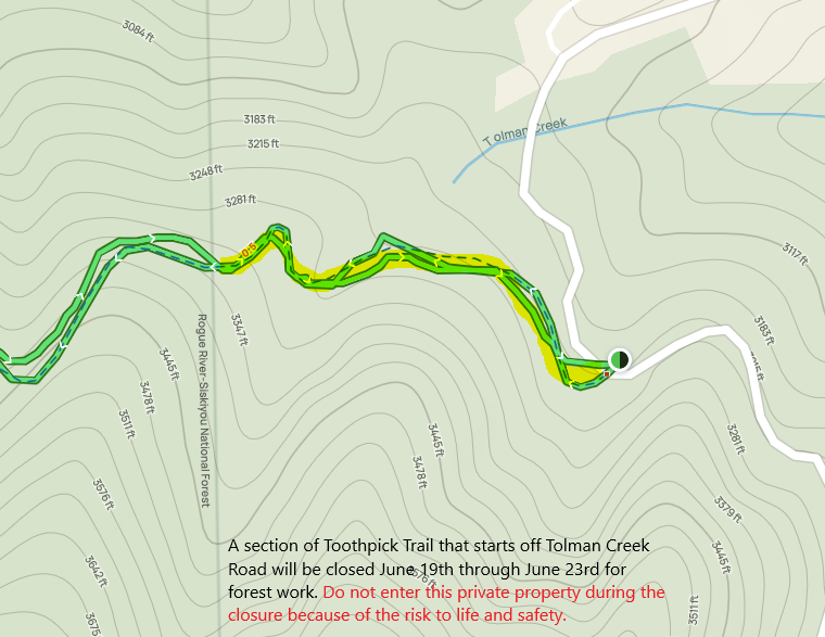
The City of Ashland Oregon is sharing the closure as a courtesy to the landowners who are completing a forest management project on land that borders public lands. The Toothpick Trail starts on Tolman Creek Road on private land and continues on to public land. Thank you for your patience during the project work.
This project is not managed by the Ashland Forest Resiliency Project or City of Ashland.
Due to hazardous tree removal and thinning for improved forest health, the Tolman Creek end of Toothpick Trail (which is on private property) will be closed for your safety.
Closure area map:
The City of Ashland Oregon is sharing the closure as a courtesy to the landowners who are completing a forest management project on land that borders public lands. The Toothpick Trail starts on Tolman Creek Road on private land and continues on to public land. Thank you for your patience during the project work.
This project is not managed by the Ashland Forest Resiliency Project or City of Ashland.
Online City Services
UTILITIES-Connect/Disconnect,
Pay your bill & more�
Pay your bill & more�
Connect to
Ashland Fiber Network
Ashland Fiber Network
Request Conservation
Evaluation
Evaluation
Proposals, Bids
& Notifications
& Notifications
Request Building
Inspection
Inspection
Building Permit
Applications
Applications
Apply for Other
Permits & Licenses
Permits & Licenses
Register for
Recreation Programs
Recreation Programs